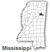
Clay County was created April 4, 1872. Named in honor of American statesman, Henry Clay, Clay County was originally organized from parts of Chickasaw, Lowndes, Monroe and Oktibbeha Counties, and named Colfax County after Schuyler Colfax, Vice-President in the Grant administration. In 1876, the Mississippi legislature changed the name to Clay County.
Its county seat is West Point. There are no other incorporated towns in Clay County; however, there are several smaller towns and communities such as Cedar Bluff, Pheba, Montpelier, Abbott, Griffith, and Siloam. With the Tombigbee River bordering the eastern side of the county and its railways and major highways, the county offers excellent transportation arteries to industry. With its centralized location being in the heart of the Tupelo, Columbus, and Starkville area, the people of Clay County have easy access to numerous universities, airports, industries, and leisure activities.
The county has a total area of 416 square miles and a population of approximately 21,979. Clay County is bordered by the counties of Chickasaw, Monroe, Lowndes, Oktibbeha, and Webster.


